Where the day changes
The following article by A M W Downing, M.A., D.Sc., F.R.S., was published in the Journal of the British Astronomical Association 10 (1900), 176-178. We give a version below.
Where the day changes.
It is unnecessary to remind the Members of this Association that when travelling east-ward from this country, for instance, the local time is ever more and more in advance of English time, and that the reverse is the ease when travelling westward. So it comes about that by the time the traveller, in the first case, reaches the 180th degree of longitude his time is 12 hours in advance of the time of his initial meridian, and, in the second case, is 12 hours behind that time. Thus, when it is six o'clock of the afternoon of Wednesday in London, to the eastward-going traveller (in the case supposed) it is six o'clock of the morning of Thursday, whilst to the westward-going traveller it is, at the same time, six o'clock of the morning of Wednesday. To set things right, therefore, it is necessary, in the first case, for the traveller to call two successive days "Thursday," and, in the second case, omitting the Thursday altogether, to pass from Wednesday to Friday. This is the practice observed in ocean-going ships when crossing the 180th degree of longitude, and is sufficiently familiar to us stay-at-homes by the many travellers' tales we have read, the authors of which give us humorous or sentimental reflections on the subject, according to temperament. But there is another point in connexion with this matter to which I wish to draw your attention more particularly. It is this. Where does the day change for the portions of the continents and the islands which are contiguous to the 180th degree of longitude, or, in other words, what is the course of the date line (as it is called) from the Arctic to the Antarctic regions? When it is Wednesday on the east side of the date line it is Thursday on the west side, and the day may be considered to begin at this line.
It is obviously most convenient that the date line should approximate, as closely as political and other circumstances will admit, to the 180th degree of longitude. Prior to about the middle of the present century this was far from being the case. Up to that time the Philippines kept the American date, owing to the fact that the Spaniards originally approached those islands from the Pacific Coast of America, Thus Luzon and Celebes, though on the same meridian, kept different dates, the former the American, the latter the Asiatic. To remedy this inconvenience the Archbishop of Manila decreed that the 30th December, 1844, should be immediately followed by the 1st January, 1845, thus adopting the Asiatic date for the archipelago under his jurisdiction.
The purchase of Alaska by the United States had also its effect in straightening the date line, as this territory which had formerly kept the Asiatic date, from henceforth, of course, adopted that of America.
Further changes in the direction of the assimilation of the date line to the 180th meridian would, at present, be difficult, as its course is mainly determined by the grouping of the islands, and by the particular circumstances in each group upon which depends the direction in which it has intercourse with the outer world.
These circumstances may, of course, alter as time goes on. and may be followed by corresponding changes in the position of the date line. But the assimilation, if carried out at all, must be a gradual process.
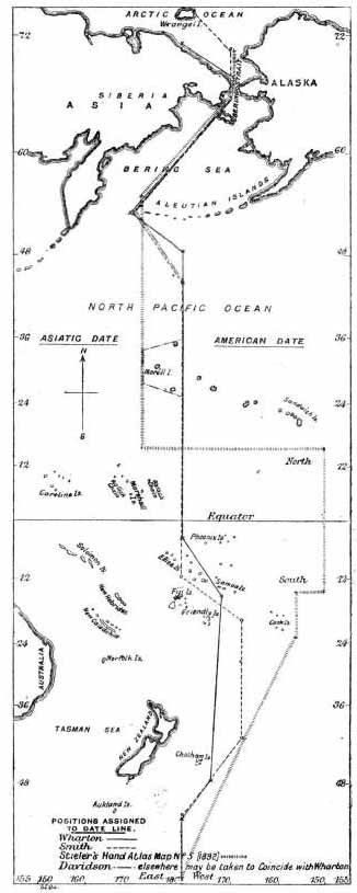
A glance at the accompanying map will show the strange disagreement that, at the present time, exists in the position of the date line as laid down by the different authorities I have been able to consult. The most remarkable divergence is in the case of the line given in Stieler's Hand Atlas. But as the atlas is dated 1892, this position of the date line may, perhaps, be considered as not being quite up-to-date. The line marked "Wharton" is that of our own Hydrographic Office, and was kindly communicated to me by Admiral Sir W Wharton; that marked "Smith" is taken from an interesting article in the Century Magazine for September of last year, by Mr Benjamin E Smith, who, however, does not give his authority for the position of the line; that marked "Davidson" is due to Prof Davidson of the University of California, and was kindly communicated to me by Prof Harkness, of Washington.
It will be noticed that Wharton and Davidson only differ in unessential particulars, affecting one small group of islands. We may, therefore, conclude that we have in these two lines an almost certainly accurate delineation (with the exceptions referred to) of where, at the present time, the day changes.
Last Updated June 2021